
Audits, Testing & Commissioning
Expertise is hard earned and when it comes to electrical safety systems of any variety it is important to have people who know what they are doing. Earthing Services engineers are often sought to oversee or intermittently audit the ongoing effectiveness of electrical earthing systems. Other times Earthing Services is required to validate the works that other companies have undertaken to ensure that it meets with the requirements of a design or specification. Testing and commissioning services are generally required at the end of an installation project and in many instances where Earthing Services has provided design and specification services the company’s engineers return to site and ensure that performance has been achieved to enable a DNO to power or energise a site.
Prior to testing: planning and geographic determinations
It is extraordinarily unlikely to encounter sites requiring audits or testing and commissioning services with the exact characteristics of a site previously visited by Earthing Services engineers, however the strategies for meeting the specific demands of a site are transferable from the enormous volume of experience within the testing team. Audit services usually incorporate an amount of testing activities and as such similar geographic determinations regarding routes and accesses are made. The initial desktop survey enables a decision to be made about testing locations in advance as well as strategic “back up” sites in the event that the primary locations are unavailable.
Earthing Services is a rarity in its thoroughness with this aspect of planning, but this contributes to the success the company enjoys in terms of its performance. Clients are safe in the knowledge that if Earthing Services engineers attend a site they are going to be trained, experienced, well-briefed, and focused on achieving the common goal of obtaining a useful, and meaningful certification for the site.
Prior to testing: development of task specific documentation
Earthing Services engineers can draw on their decades of construction and power knowledge when visiting a site, but this has to be supported by site specific documentation containing the outputs of the various plans made in advance of site attendance. Audits regularly require lateral thinking and responding meaningful to evidence on site and as such the site documentation may not be exhaustive in its order of approach, however it shall contain all necessary plans and health and safety information to enable the operatives behave in an appropriate manner, and for customers to be safe in the knowledge that the engineers are acting responsibly.
Prior to testing: Equipment check and preparation
Testing equipment is fully prepared and checked prior to the departure of the testing engineers to avoid any confusion or problems when the team arrives on site. Earthing Services engineers recognise the importance of having charged, calibrated, and well maintained instruments otherwise all plans may not be executable.
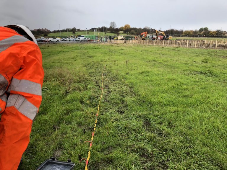
Testing activities: Travel and initial audit
Earthing Services testing engineers recognise that their work begins whilst they are still travelling to a site. Visual assessments of landscapes can provide a trained eye with a wealth of information that will contribute to the portfolio of evidence that is sent back to the office for processing. Being able to identify and interpret landmasses through their relationship to the rest of their environment is incredibly useful. Questions that occur to engineers during their approach include examples such as, “what is the relative height above sea level?”, “has this area been subject to erosion?”, “has this area seen substantial landscaping or earth movement, which may have disturbed or disrupted the natural tiering within the earth?”, “has the weather been particularly wet, cold, or arid, recently?” and all of the thoughts these sorts of questions prompt help inform the later analysis of data.
When the engineers arrive at site they may well have to be inducted, receive a briefing, or hold a meeting with the client’s representatives, and all of the time they will be evaluating how the activity on site, both current and historic, may have impacted upon the sub-strata. Prior to setting up an electrical earthing system test it is common for Earthing Services engineers to visually inspect the area, including assessments on local flora and fauna. Mature trees or sub surface agricultural elements can distort or bias electrical resistance within the ground and as such must be avoided and “reading” the landscape is something that Earthing Services engineers are trained to do.
Testing activities: electrical earthing system testing
Undertaking effective testing activities verifies electrical earthing system performance, and as such this is the most important stage in the process. For the majority of electrical earthing system tests Earthing Services engineers will have at least two Megger DET 2/2 devices with them to undertake and verify the test; these testing devices are quite expensive and other companies frequently buy alternative instruments and advise that they perform comparably, however this has not been proven to be the case in the experience of a number of Earthing Services engineers. Earthing Services demands the best performance from its equipment because that is the standard of service it wishes to offer its customers.
A test will require a suitable connection with the electrical earthing system in question, and then extend cables to establish a reference earth some distance away (determined by the size of system under test). The methodology used will determine the method of calculation and the characteristics of the intervals at which readings and measurements shall be taken. Many tests may look identical to the untrained eye they may differ quite significantly and interpreting the values obtained requires the assessment of experienced engineers.
Testing activities: methodology – Slope, Fall Of Potential (FOP), Dead Earth
Different electrical earthing systems may require different testing methodologies to yield the most meaningful information from the site. It may also transpire that the client, or third party authorising body have specific testing requirements and will not accept data obtained by any other method than their preferred. Fortunately Earthing Services engineers, both in-house and site based, have voluminous experience with all of them.
Testing activities: Transmission of data set
As soon as Earthing Services testing engineers have completed their activities on site they aggregate it into a package of information, comprising everything that they have obtained and transmit it back to the servers at the Nottingham office. Using specialist software the package of information is decoded and at that point work on computation can immediately begin. This aspect of Earthing Services’ electrical earthing system testing is one of the most popular because it circumvents any delay, or potential loss of paper based documentation.
Testing activities: Computation of data set
As indicated by the previous stage, electrical earthing systems cannot be certified simply from an engineer turning on a test instrument, the data needs to be analysed to ensure that the information evidences effectiveness. Possessing knowledge of location of test and the geographical characteristics of it enables Earthing Services earthing engineers to fully assess compliance and determine the performance attributes of the site. This evidenced performance is then compared to the theoretical performance value identified at design stage, which will yield information as to the quality of the installation.
Testing activities: Transmission of completed report
Once all computational activities have been resolved a report is prepared for issue to Earthing Services’ customer. In the event that the customer in question used Earthing Services for the design and specification phase of the project then it is highly likely that the original design report will be revised to enable direct comparison between the theoretical value and the achieved value.
If you would like to learn more about Earthing Services’ construction phase auditing, testing and final commissioning services then please feel free to get in touch via the contact page, or call the Nottingham office.