Before a soil model can be produced a soil resistivity survey must be conducted to obtain input data for analysis; to learn more about this service that Earthing Services offers please refer to the dedicated service page on this website for soil resistivity surveys. Soil modelling and and analysis is the process of computing raw data obtained from a site specific soil resistivity survey and then interpreting its outcome. The purpose of undertaking both soil resistivity surveys and soil modelling is to establish the characteristics of how the ground in a particular location dissipates electrical current. The information gained from such activities provide input data for creating an electrical earthing system design, as the soil modelling and analysis instructs how the location will dissipate electrical current in the event of a fault current event.
Some organisations dispute the need for undertaking either full, and approved methodologically based, soil resistivity surveys or the soil modelling that follows them. Earthing Services considers this legacy mindset to be backward looking, willfully neglectful, and evidence that those organisations lack sufficient electrical earthing knowledge to warrant passing an opinion on the subject; after all it is surprising how unnecessary any service or product seems when you cannot offer it and do not understand – thankfully Earthing Services has the expertise and capacity to support customers in this way.
Remember, if you have undertaken a soil resistivity survey but do not have access to the software which processes the results please get in touch, we can process that on your behalf for a small fee.
When Earthing Services engineers undertake a soil resistivity survey they package the data set, along with an amount of other relevant information back to the servers in the Nottingham office whereupon the design team immediately analyse it to ensure that the obtained results are sufficient for development into a soil model. CDEGS software helps engineers interpret the data and determine anomalous results.
Soil modelling communication: Confirmation of acceptability to site engineers
Earthing Services office-based engineers responsible for evaluating transmitted data sets can swiftly determine the acceptability of a data set for advancement to soil modelling stage. In the rare case that the transmitted data is unacceptable then the site testing team will undertake further testing and transmit again; for more information on this aspect of Earthing Services’ provision please refer to the dedicated soil resistivity testing page of this website or get in touch through the contact page of this website. In the event that the data set is approved then the office engineering team will communicate to the testing engineers on site that they are able to cease the testing process.
Soil modelling: Data input and processing through CDEGS
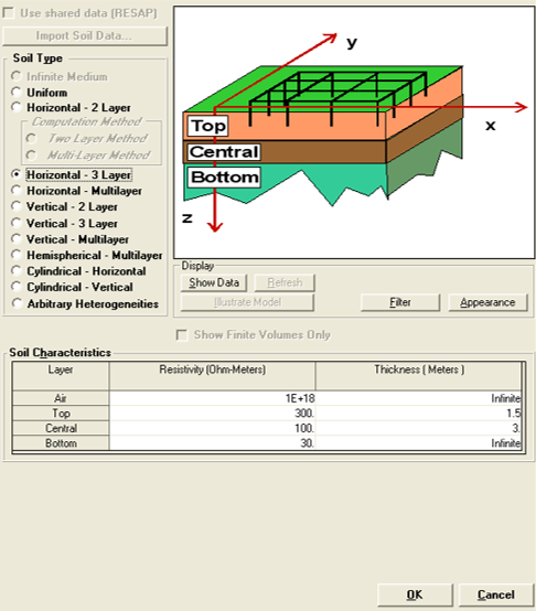
Once the dataset has been determined to be acceptable it is processed by Earthing Services technical engineers to convert it into a useful, and easy to comprehend soil model. Having trained engineers who are familiar with CDEGS enables Earthing Services to quickly crunch the numbers to establish the likely structure and electrical conductivity of the ground beneath the testing locations. Following this the software generates a soil model for analysis and evaluation.
Soil modelling outputs: Evaluation of computed output
When Earthing Services engineers have completed the processes that generate the soil model it is important that the output is thoroughly analysed and peer reviewed. As it is possible to convert every soil resistivity survey “run” into a soil model, and as Earthing Services testing engineers will often undertake as many as twelve runs over two testing instruments, it is possible that twelve soil models will be produced. It is at this time that Earthing Services’ experienced engineers will interpret that data set and be able to determine the most representative of the sub-strata of the site in question.
Soil modelling ouputs: Generation of soil model
When all soil modelling computation is complete and a soil model is evaluated and reviewed it is imperative that customers receive the information and that it be presented in a fashion which they can easily comprehend. The soil model is presented in tabular format, supported by evidence in the forms of graphical presentations, the data harvested from the soil resistivity surveys and also the computed results.
Soil modelling outputs: Compilation and submittal of report
Once all documentary evidence and design outputs are produced they are aggregated into a report, which is then transmitted to the customer in an appropriate way. The reports are clear, concise, and above all accurate, and it is for this reason that so many customers find their way to Earthing Services.