
Soil Resistivity Survey
Before an electrical earthing / grounding system can be installed a few other activities must first be undertaken. Historically installation companies may have offered to drive a single earth rod and take a range of readings from it at various depths as it is driven in to the ground. To say that this is better than nothing, or a reasonable compromise, is comparable to saying that keeping your fingers crossed will ensure that you win the national lottery.
The only thorough, scientific and logical method of determining an electrical earthing system is to undertake a complete soil resistivity survey to an approved methodology. Earthing Services does not endorse anything other than the professional approach when obtaining information that will provide the basis for decisions on electrical earthing systems. The importance of this variety of life saving, critical safety system, demands that determinations on requirements are based upon accurate, meaningful and useful data, which is exactly what Earthing Services provides.
Harnessing the wealth of information about the electrical behaviours of soil masses throughout the globe enables Earthing Services to bring that knowledge to contribute to the analysis of each new project. Earthing Services calls upon its database of soil models, along with first hand experience of the geology of an area, including the influences of seasonal variations in climate, to make astute soil profiling decisions about its customers’ projects.
Earthing Services engineers undertake soil resistivity surveys for numerous customers on a regular basis, and these services have been conducted all over the world. Feedback from a number of new customers (who have previously subcontracted soil resistivity surveys to other companies), has brought to our attention that Earthing Services’s turnaround time from the commencement of testing to the client’s receipt of processed results is faster than competitors by a considerable margin.
The speed with which Earthing Services is capable of obtaining data from site and computing it is largely down to the combination of motivated, trained, and incentivised staff, and state of the art methods of capturing and transmitting data from site to the servers at the Nottingham office. Incoming data is planned and it is normal practice for an engineer to be primed for the information to arrive so that no time is lost in converting the raw statistics into meaningful results. When it comes to effectiveness Earthing Services ticks all of the boxes, from cost efficiencies all the way to providing the processed results within a time efficient duration.
If you have undertaken a soil resistivity survey but do not have the software to process it into a soil model please feel free to get in touch, we will process that on your behalf for a small fee.
Prior to testing: planning and geographic determinations
From the moment the company receives an order which requires a soil resistivity survey Earthing Services engineers commence the desktop planning stage of the project. Our trained team knows how to assess the practicality and usefulness of a given area when it comes to undertaking soil resistivity surveys, and this can begin using topographical data, location coordinates, and plotting technologies.
A single “run” or collection of soil resistivity data requires approx. 170m of uninterrupted open land (soil-type ground mass), and this enables the engineers to assess the electrical resistivity attributes of the ground to a depth of over 50m. It is usual that the lower the depths, the more stable and generally better, the electrical resistivity performance. In the event that less land is available it is not uncommon to do shorter (and therefore shallower) soil resistivity surveys, however this results in a less exhaustive dataset. Due to the specific geographic requirements for undertaking soil resistivity surveys there are occasions where this is unavailable at the project site and alternative locations have to be used.
Despite these seemingly stringent constraints due to Earthing Services’ commitment to its customer base, the company’s engineers have always obtained accurate, meaningful, data that will capture the sub-surface electrical characteristics of a site. The company is able to do this based upon knowledge of the stability and greater uniformity that lower depths offer across larger distances and of a knowledge that Earthing Services has a reputation built upon maintaining an excellent standard of service to its clients that demands the harvesting of a meaningful, useful data set. The initial desktop survey enables a decision to be made about testing locations in advance as well as strategic “back up” sites in the event that the primary locations are unavailable.
Earthing Services is a rarity in its thoroughness with this aspect of planning, but this contributes to the success the company enjoys in terms of its performance. Clients are safe in the knowledge that if Earthing Services engineers attend a site they are going to be trained, experienced, well-briefed, and focused on achieving the common goal of obtaining a useful, and meaningful data set.
Prior to testing: development of task specific documentation
When a company regularly undertakes the same variety of service it is not uncommon to see standard method statements, risk assessments, and other documentation referenced or presented to a client; Earthing Services is different in this regard. The normal workpack that site engineers receive in advance of travelling to site includes task and location specific method statements, which will detail on special measures or precautions for the site; task and location specific risk assessment, which will identify hierarchies of potential hazards, and control measures; satellite photographs, topographical drawings, and any applicable construction drawings for primary, secondary and even tertiary testing options and any other required project specific documentation. Earthing Services takes planning these activities very seriously because the data obtained from soil resistivity surveys is vitally important.
Prior to testing: Equipment check and preparation
A company could use the right method, have a wonderful docket of information and planning, but if the equipment that they send to site is incapable of obtaining an accurate reading then the whole process is deeply flawed. Earthing Services is proud to be different. All testing instrumentation and ancillary equipment is calibrated and maintained and as such there is 100% confidence that the provision of resource to testing engineers is going to get the job done. When it comes to testing instrumentation, despite the claims of many, every device is not the same, and every device does not perform in an equivalent manner to everything else on the market. Earthing Services has undertaken its own research and trialing with an array of brands and varieties of testing equipment and has come to its own conclusions. The testing instruments sent to site are not only calibrated they are also able to test significantly large facilities such as power stations, and do this to a very high level of accuracy even in challenging environments; they may be expensive, far more so than many companies would send to site for a soil resistivity survey, but the Earthing Services Technical department is of the opinion that it makes the most sense to put the best, most reliable and accurate testing equipment at the front end of a project when it can contribute the most to providing a safe, correctly specified, economically installed electrical earthing system.
Testing activities: Travel and initial audit
Earthing Services testing engineers recognise that their work begins whilst they are still travelling to a site. Visual assessments of landscapes can provide a trained eye with a wealth of information that will contribute to the portfolio of evidence that is sent back to the office for processing. Being able to identify and interpret landmasses through their relationship to the rest of their environment is incredibly useful. Questions that occur to engineers during their approach include examples such as, “what is the relative height above sea level?”, “has this area been subject to erosion?”, “has this area seen substantial landscaping or earth movement, which may have disturbed or disrupted the natural tiering within the earth?”, “has the weather been particularly wet, cold, or arid, recently?” and all of the thoughts these sorts of questions prompt help inform the later analysis of data.
When the engineers arrive at site they may well have to be inducted, receive a briefing, or hold a meeting with the client’s representatives, and all of the time they will be evaluating how the activity on site, both current and historic, may have impacted upon the sub-strata. Prior to setting up the first soil resistivity survey location it is common for Earthing Services engineers to visually inspect the area, including assessments on local flora and fauna. Mature trees or sub surface agricultural elements can distort or bias electrical resistance within the ground and as such must be avoided and “reading” the landscape is something that Earthing Services engineers are trained to do.
Testing activities: soil resistivity surveys
Whilst this stage is notionally the “main event” without thoroughness at each stage leading up to it, and indeed following it, the soil resistivity survey data may be insufficient to confidently specify an effective, safe, electrical earthing system. Some companies offer a less thorough service by opting to undertake single runs, and therefore obtain data from only one test. Earthing Services engineers not only endeavour to verify data for each run on a second test instrument, but also undertake secondary locations, and even tertiary locations to substantiate and broaden the data set. By pinning the soil resistivity data to exact geographic locations results in Earthing Services design engineers being able to interrogate the data and further interpret the ground beneath surface level.
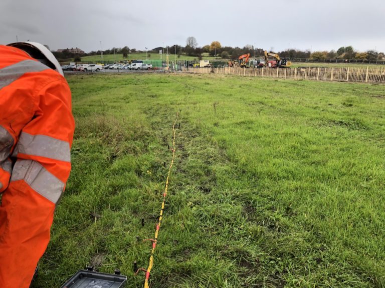
When a test is set up and ready to take place it is common to see Earthing Services’s specialist cables extending along the length of the ground with numerous small test electrodes installed at various integers. As explained in earlier stages, the cables are long, and require approx. 170m of open ground (for further discussion on this please see “Prior to testing: planning and geographic locations” nearer the top of this page). The test electrodes are controlled and activated using proprietary technology at the centrepoint of the test, which is also where the test instrumentation is situated; this enables the testing engineers to direct electrical current to specific probes and measure their behaviour through the ground. It is worth considering that the spacing between the testing probes that are activated is the depth to which the electrical current will travel. To further elaborate on the previous point, if the testing probes at 1.5m separation are activated the electrical current will penetrate 1.5m into the ground, similarly, if those at 54m spacings are activated the electrical current will penetrate 54m into the ground.
Testing activities: methodology – Wenner or Schlumberger
When it comes to undertaking soil resistivity surveys there are two approaches to consider, the Wenner method, and the Schlumberger method. On face value nearly everything about the two approaches is identical, and that is one of the reasons that many people disregard this as a point unworthy of discussion. The variations in the mathematical processes demands that whatever processing method is adopted it must be carried through to completion; self evidently, part way through a mathematical formula one cannot simply commence a different process. The Wenner method is the most commonly used formula in the industry but this is not to say that the Schlumberger method does not have its merits. In every Earthing Services report relating to soil resistivity surveys there will be a section identifying the approach adopted.
Testing activities: Acquisition of other design input data
Whilst the testing engineers are on site they will aggregate a quantity of other information that may be useful for the interpretation of the data obtained. Photographs, soil samples, organic interference evidence, an examination and detailing of any other identified electrical earth systems that may not have been previously advised before the date of the soil resistivity survey, and an identification of any other source of electromagnetic interference will all help inform decisions back in the office.
Testing activities: Transmission of data set
As soon as Earthing Services testing engineers have completed their activities on site they aggregate it into a package of information, comprising everything that they have obtained and transmit it back to the servers at the Nottingham office. Using specialist software the package of information is decoded and at that point work on computation can immediately begin. This aspect of Earthing Services’s soil resistivity service is one of the most popular because it circumvents any delay, or potential loss of paper based documentation.
If you would like to learn more about Earthing Services’s soil resistivity surveys then please feel free to get in touch via the contact page, or call the Nottingham office.